North Fork Yellowleaf Creek
-
RunNorth Fork Yellowleaf Creek
-
ClassIII-III+ below 26", IV above 26"
-
Put InOld Hwy 280 @ Ivy Branch
-
Take OutOld Hwy 280 pulloff
-
Length (mi)0.5 or 1.5
-
Gradient (fpm)80 (0.5) or 120, 20 (0.5)
-
Watershed (mi2)4.7
-
Primary Gage
- None Visual**
-
Indicator Gage
Description
North Fork Yellowleaf Creek, just off Highway 280 south of Birmingham near Oak Mountain State Park, could be either a 0.5 mile or 1.5 mile run. The 1.5 mile run would be from the Ivy Branch confluence through the Big Narrows, then through the Narrows, ending at the first major confluence from river right downstream of the Old Hwy 280 / CR 377 (Mountain Crest Rd) intersection. Here are the details on the first 0.5 mile run starting at the Ivy Branch Confluence through the Big Narrows from Judson Douglas:
The put-in is on Old HWY 280, where the Ivy Branch (which goes under the road) and Narrows creek come together. There is a place to pull off, and could hold about 4 cars. The take-out is on Old HWY 280, .5 miles from the put-in (there is a pull off there), you take 2 steps away from the creek and you're in your car!
You should really look at all drops on this creek before you run it! The creek starts off with some fun class II drops and rapids. There are about 5 before the first big drop. Ah the first drop…, NICE. It is about 6 feet all together. If you run left (harder) you have to do a really hard right turn, and if you don't bad things can happen - "broken bones" from smashing into a large rock. If you run right it's almost a vertical drop, but you will need more water than what I ran it with. After that you have a 30-foot slide that drops some, but not a lot. Then you have what we call "solar falls" which drops about a foot (we named it this because of the solar panel that is up on the road). Then you have a good class III tight move on river right. Not hard, just fun. After this it's just class II rapids similar to Graves Creek for about 30 yards.
Now all the hard stuff. You come around the creek and have a good class III rapid, this makes a right hand turn. If you roll here then you could get hurt-there are many sharp rocks in the creek bed. Then you come to the first semi-pool of the creek (10 feet). After that you come to a slide that drops about 7 feet (note: all the water goes into a wall-approximately 12 feet high-they built by the creek, this is a really good\hard class III\III+. Next is a class II rapid the has a bad tree in it (I walked it). Next is a class III drop into a slot. It drops about 2 feet, but the creek narrows to about 3 feet wide and all the water goes in this drop.(water goes into a rock, very tight). Experienced boaters could get hurt. 5 feet after that, there is one more very tight slot. It about the same as one above.
Now the biggest drop on the creek. It's about 7 feet into a pool that is very turbulent, and there is a 3 foot drop out of it. Fun!!! Now you get to take a break. There is a 30 foot long pool before the rest of the drops. The most costly rapid on the creek is next. We call it the "Guillotine;" the reason why is because it will take you head off. This would happen because all of the creek drops into a 2 foot wide slot for about 8 feet. On the right there is a solid rock wall, that all the water goes into and then runs down it. On top of the wall there is a little 5 inch hangover that is sharp.(Try to stay away from it.) The next drop is the oddest one I have ever seen (and I have seen a few), it's about 3 feet all together, class II, and words just can't describe it. Fun. After this you have about 70 feet to the take out mostly with class II rapids.
The put-in and take-out are on public land as far as I know. I had no problems with anyone. So far, so good.
Minimum is 3"-4" above the bottom of a small tunnel at the put-in. 8" to 12" above the bottom would be about medium and 14" and up would be high. At 30" there are big big holes. At maytag falls the whole creek narrows down to about 7', and there is a monster hole at the bottom of this drop. It's so big that it back indered me and sent me 2' into the air. It also kept me and my boat. I did swim out about 2 minutes later, but it dragged me right back in and recirculated me about ten times. After I got out, it held my boat for about ten minutes. This was quite a hole. It reminds me of the bad hole near the bottom of Short Creek (Little Woody). If there is about a 1 inch rain the Narrows runs about 12 to 20 inches. This means possible summer runs if you can get there quick enough!!
Details
-
ClassIII-III+ below 26", IV above 26"
-
Gradient (fpm)80 (0.5) or 120, 20 (0.5)
-
Length (mi)0.5 or 1.5
-
Watershed Size (mi2)4.7
-
Put InOld Hwy 280 @ Ivy Branch
-
Take OutOld Hwy 280 pulloff
-
ShuttleOld Hwy 280
-
Water Quality
 (
2 chickens | 1 = Good, 3 = Gross)
(
2 chickens | 1 = Good, 3 = Gross)
-
Primary Gage
- None Visual**
-
Indicator Gage
-
Precip. Gage
Map
Video
Photos
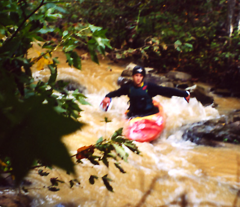
Judson Douglas in a warmup class II (photo courtesy Judson Douglas)
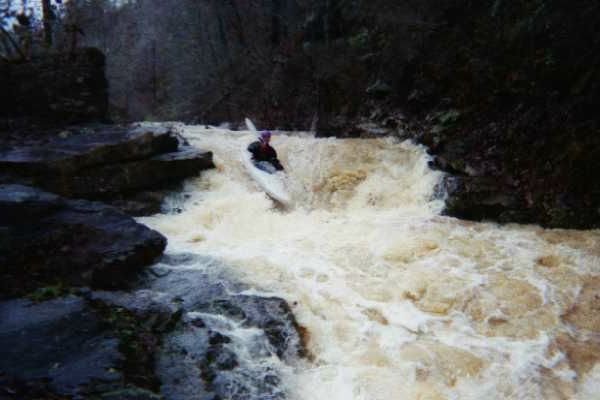
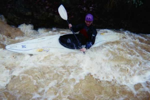
The level measured 36" from the bottom of the drain pipes that flow under old 280 at the put in for this picture and the next. The first is the biggest (...)
The bottom of the "Guillotine" after I ran it backwards (not my original plan but it worked). (photo courtesy Tod McChesney)