Bear Creek (LRC)
-
RunBear Creek (LRC)
-
ClassIV
-
Put InRt. 176
-
Take OutLittle River Canyon
-
Length (mi)2.6
-
Gradient (fpm)90, 140, 100 (0.6)
-
Watershed (mi2)12.1
-
Primary Gage
- StreamBeam Bear Creek 0.8' (StreamBeam)
- Put-in bridge 2" (Hwy 176 Bridge)
-
Indicator Gage
- Little River near Blue Pond 4500 cfs
Description
How can it be a class 4 run with no class 4 rapids? There must be some in there somewhere. Only runnable a few times a year and will drop out in a day except after really big rains. This is a superb run if you like not too threatening class IV low volume creeks. Pool drop for the most part. Watch out for a hole about halfway in (It has been marked in the past by a small rock cairn). It is guarded on both sides by rocks, so if you get stuck, you may have trouble getting out. If you have never run it, all rapids can be boat or bank scouted with relative ease. One of the trickier rapids is towards the bottom. It features two small offset diagonal curler holes just above a 6' drop. Take out at the Chairlift (grunt) or paddle to the canyon mouth park.
Historically, this run was judged using a painted gauge on the put-in bridge. 0' is minimum, 4" is medium, and 8" is pushy and big (those familiar with the run prefer 4" minimum, with 8" being ideal). However, an online gauge has been installed by the folks at Streambeam which allows the current level to be checked before leaving the house. This gauge updates several times per hour, and appears to correlate well with the existing stick gauge. Look for 0.75' to scrape down, and about 1.3' for good flow; if it's over 2', watch out, because the whole run will turn into a freight train down into the canyon. The correlation between the bridge and Streambeam gauges is still being developed. The gauge can be accessed at the link below; timestamped visuals of the put-in gauge can also be submitted via the Streambeam site to solidify the correlation.
Streambeam Bear Creek (LRC) Gauge
This run can get too high, though it takes lots of rain. Here are some comments from Jed Dugger:
8" on the gauge and the canyon was running at about 10,000 cfs, or 9.5' at canyon mouth park. What a great run at this level. Very pushy, but the rocks are covered and lines are much cleaner. Now when you get to the canyon, running the lower 6 miles is quick with only one rapid. You guessed it, Bottleneck. Huge waves and holes. You can paddle the sneak on the right, where you normally portage this rapid, or get into the eddy on the left, 75 yds above the rapid. There is a small, straight ahead rapid on the left leading down into the eddy. Go to the end of the eddy, peel out into the center flow and follow the tongue down the middle. Monster holes, both left and right. The tongue goes right down the center. There is a small reversal at the bottom, BAM, you are through into the pool below. At this level the water at the takeout will be only a foot or two from the road elevation. The trip takes only about 25 min. Have fun. JED
Details
-
ClassIV
-
Gradient (fpm)90, 140, 100 (0.6)
-
Length (mi)2.6
-
Watershed Size (mi2)12.1
-
Put InRt. 176
-
Take OutLittle River Canyon
-
ShuttleRt. 176 / CR 43 / CR 275
-
Water Quality
 (
1 chicken | 1 = Good, 3 = Gross)
(
1 chicken | 1 = Good, 3 = Gross)
-
Primary Gage
- StreamBeam Bear Creek 0.8' (StreamBeam)
- Put-in bridge 2" (Hwy 176 Bridge)
-
Indicator Gage
- Little River near Blue Pond 4500 cfs
-
Precip. Gage
Map
Video
Photos
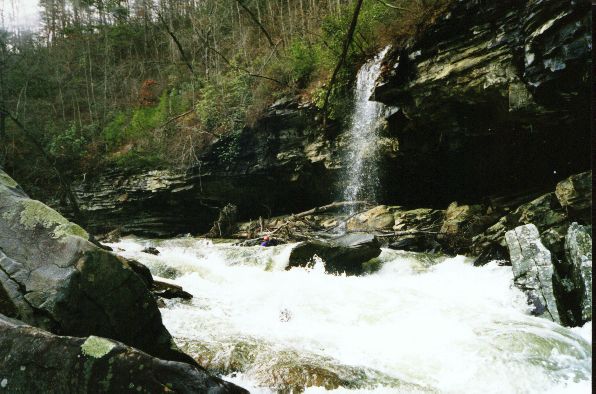
A nice scene in the middle of a long rapid on Bear.
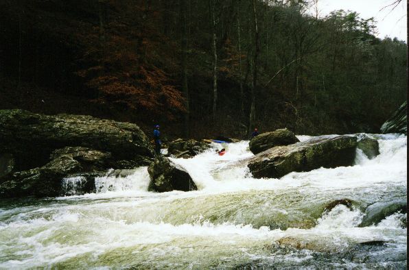
John Parker giving that shoulder a workout.