Shoal Creek (Union Grove)
-
RunShoal Creek (Union Grove)
-
ClassIV/IV+ (V+/P)
-
Put InCR 240 / CR 50
-
Take OutButtery Rd
-
Length (mi)2.7
-
Gradient (fpm)
-
Watershed (mi2)27.3
-
Primary Gage
- CR 240 Bridge ** 0' **
-
Indicator Gage
- Locust Fork near Cleveland 4.0 ft.
- Town Creek near Geraldine 650 cfs
Description
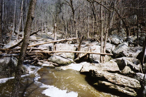
Brad Hinds thinks it's a blast, Keith Yell said there were big drops, and Ricky Pollard had nothing nice to say. So we tried it, and we liked it. In fact, this would be one of the best IV/IV+ runs around except for the big portage. As it is, with the put-in glamour rapid and various other fun rapids, it is worth a try at a good water level. This creek is definitely 3 chicken water, though it may not be chickens alone...Overall it is class IV, with perhaps a little episodic IV+. Some rapids require a few linked moves. It is drop/pool but continuous here and there, and the rapids have character, they are not just boulder gardens. There are a two fun slides and a few rapids that are fairly long. Scouting is a good idea if you have not run it before. As of late 2009, the top part is mostly clear because we cut it out in the fall of 2008, but starting with the 3rd rapid after the big portage, there are several logs, some of which are in bad spots. Keep a heads up and cut it out if you are motivated.
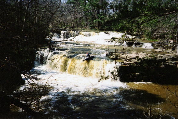
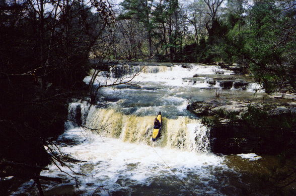
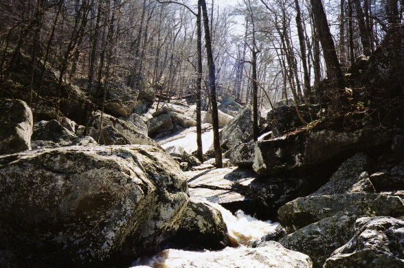
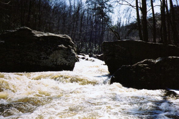
Shoal "in the Grove" starts off with a pretty easy and highly photogenic double waterfall (about 12'-14' per drop) at the former site of Neighbors Mill. If you ask nicely, you can park and put-in right next to the BP gas station on CR50 just off CR240. Then the run is class III/III+ for a while. Below a rapid where the current splits (the 3rd picture on the picture page), there is a severely undercut boulder. Undercut on the upstream side in the current. About the height that a body or kayak is wide. There is plenty of room for an upright boater to avoid it, but a swimmer or inverted boater would be swept right into it. Easy roping from the right.
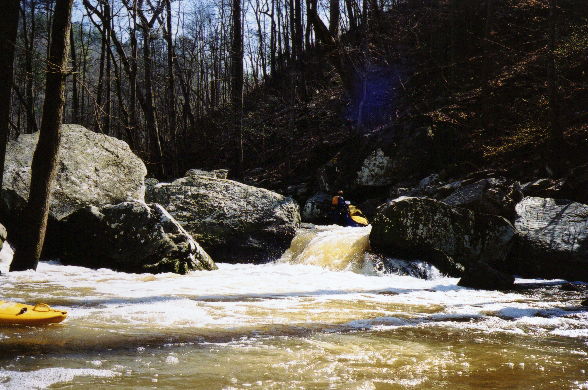
Just after this the action begins to pick up with three distinct rapids in a row. They need names but the first is easy, while Percolator has a tricky eddy on the left with a boil that can mess you up and put you in the hole. The 3rd has a big and very fun slide followed by a narrow section. You'll probably be in a eddy on the right at the bottom of it when you will confront three drops in succession, the last of which is a 6' high 45 degree slide bounded by rocks at each end. The rock on the right is very big and the hole (I call it "Curt's hole") is nasty. Getting boats and boaters out of it can be a challenge. Hit the left edge of the current and you'll be fine.
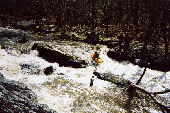
After over a mile of fun stuff, fully 120' of the total drop is eaten up by Lion's Den, one monster multi-part rapid. This thing is perhaps the biggest in Alabama on a creek of reasonable size. Comprised of several 10'-20' drops one after another, some individual components can be run by the highly skilled and psyched. It terminates with a drop and hole under an enormous balanced rock. Logs can block the entrance, so you don't to want to go there. We portage river left, which looks easier than river right.
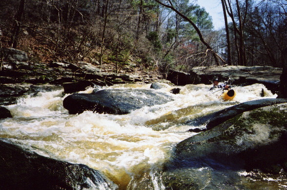
After the big one, there are a few more IVs. The first IV is the hardest, a move to the left over a boof, then a narrow passage to the bottom. A very dangerous sieve has been seen here at super low summer water levels. The next has another eddy hard to the left followed by a cool diagonal wave filled slide. The last is a narrow passage towards river left with holes which is best boofed at the end. Finally, there are some concluding III+'s that can be really bony at low water. Then you paddle the lake backwater for about 3/4 of a mile. The take-out is mighty convenient at the end of Buttery Road. It is the first paved road off CR50 on the left after CR50 starts to drop down towards the Tennessee River about 2 miles north of CR 240.
**There is a gage on the river left downstream support of the CR240 bridge upstream of the falls. 0' or very slightly less is minimum. The creek is wide here so a few inches can make a big difference. 2" is nice, 4" starts to get spicy, and 6" may be pretty high. We first ran it when the semi-flat rock between the first and second drops of the put-in waterfall had a thin but healthy film of water pouring over it. See the picture page, this was about perfect. We have run it a bit lower, but rocks were too plentiful. Too much higher and some holes will get sticky while others will be even more scary than normal, and you might wash into something you'd hoped to scout.
Below is a profile of the creek gradient. These data are not as accurate as the gradient field above but do give a graphical feel for how the gradient is distributed.
Details
-
ClassIV/IV+ (V+/P)
-
Gradient (fpm)
-
Length (mi)2.7
-
Watershed Size (mi2)27.3
-
Put InCR 240 / CR 50
-
Take OutButtery Rd
-
ShuttleCR 240 / CR 50 / Buttery Rd
-
Water Quality
 (
3 chickens | 1 = Good, 3 = Gross)
(
3 chickens | 1 = Good, 3 = Gross)
-
Primary Gage
- CR 240 Bridge ** 0' **
-
Indicator Gage
- Locust Fork near Cleveland 4.0 ft.
- Town Creek near Geraldine 650 cfs
-
Precip. Gage
Map
Video


Photos
A certain C-1 paddler finally realizing his longtime goal of running the put-in double waterfall. Looks like I actually remembered to take the last stroke (...)
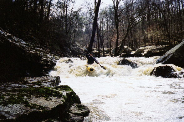
Dave makes it look easy.
Brian McAnally runs a drop just above the one spot we had to walk due to a tree. Below here is an undercut rock that may warrant safety being set.
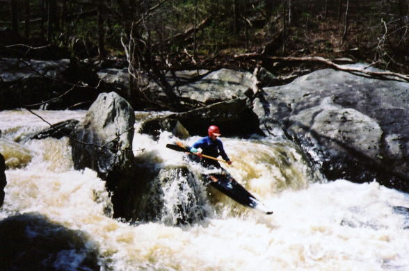
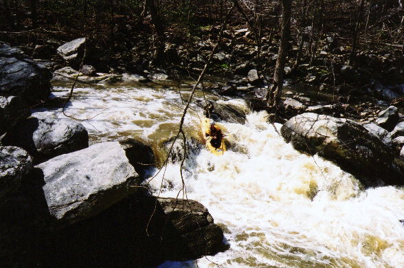
Curt Ruffing in action
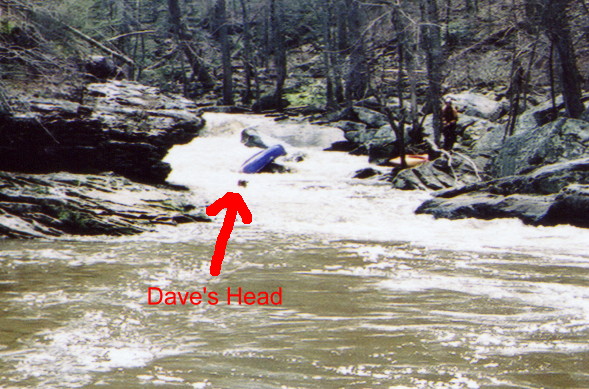
I've given up taking carnage pictures of Dave for the most part. He now runs stuff that I walk. But here I had a relapse as he and his boat part ways.
The next drop requires you to be at this point or you hit the barely submerged rock to river left. The best nway to enter is to catch the eddy on river le (...)
Curt on the next drop. One example of a hole that could get sticky at higher water.
Brian leading the way down a fun slide that cuts right towards the bottom.
The middle section of the big boy.
The last drop of the enormo-rapid goes right through all those logs into...
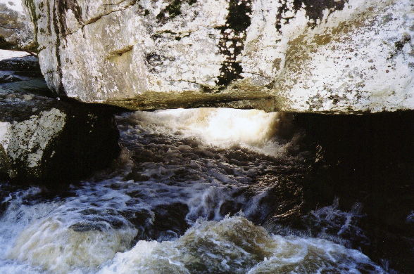
This nice little undercut/cave/room of doom, which looks pretty clean from below. The rock over the water is the same one behind the trees from the pictur (...)
Brian once again showing the line. This rapid was fairly long, it was best run over a 4' boof just out of view to the above river right, then into the edd (...)
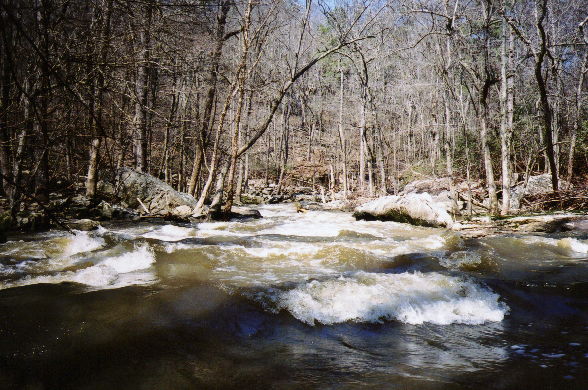
I believe this is the bottom of a really fun, semi-long (by approaching middle age-wimpy-small creek-definitely not class III-eastern-drop/pool standards) (...)
The end of another rapid, this one negotiated by Dave using the amphibious technique. This may have been the last rapid harder than class III.

Trip Reports
Shoal In The Grove
March 21, 2002
Written by Mark D'Agostino
Paddlers: Mark D'Agostino (C-1), Dave Branham (OC-1/swimfins), Curt Ruffing, Brian McAnally (K-1)
Not too often does it come to pass that a person can realize a longtime ambition, especially one thought to be just a hardship waiting to happen. For many years, Shoal "In the Grove" has been that run for me. Not to be confused with the Scarham Creek tributary, this Shoal flows into the Tennessee River just downstream of Guntersville Dam from the south side, not far from the little town of Union Grove. If you've ever driven CR 240 from Morgan City towards Guntersville, you've essentially passed over the put-in at the BP station. Many years ago, at least prior to the fall of 1995, I walked about half of it with Mike Abernathy, and about ¾ of it with John Parker. The completely dry streambed I saw through my eyes then was continuous class IV and V with undercuts and a rapid so heinous that it was actually a challenge to walk. Over the years, the run was on my 'list' but usually categorized as "stupid" or "scary". I have never met anyone who has run it more than once, except maybe for Keith Yell. If you know Keith Yell, you know this fact is inconclusive as to the nature of the run. Ricky Pollard also had nothing but bad things to say about it - one of his friends pretty much quit boating with him after they ran Shoal.
But this year, it was on my radar and I had been working Dr. Branham, who was concerned. Finally, we had a small crowd going this particular Thursday, and our plan A had too little water. So Curt, Dave, and I met Brian at the put-in. As we drove up the immediate conclusion was that the level was perfect. We wanted the first falls rapid to be a nice but not high level, and that it was. "Oh S*#t, I guess we have to run it" was Dave's response. The BP station folks had no problem at all with us parking there. The sky cleared and it was a beautiful days in the 60's. No excuses were to be found. The atmosphere was upbeat fatalism.
After running the short shuttle, we set up safety and camera coverage on the glamour shot opening double drop. The first 12' drop is run on a slide at far right, and the second is run out towards the middle left. We all had good lines, and got pretty good pictures to boot. The falls were easy, and spirits were high, if a tad nervous.
The next mile+ or so were an exercise in waiting for the other shoe to drop. The rapids were easy III to III+/IV, and at least initially pretty well spaced. After close to an hour or so, I was beginning to doubt my memory of the run. I knew that your perception of a run can be inaccurate on any scout, and back in 1995 I had not run much hard stuff. It also took me a long time to realize that water, especially high water, could make seemingly easy stuff much harder than it looked dry, but that water can also fill in lots of gaps and 'smooth out' ugly looking things as well. There were a few fun slides, only a couple trees, and generally fun class IV drop/pool rapids. Tighter than Sauty, harder than Short, very much in our comfort zone. I felt on top of my game. Brian led the way though the harder boat scout stuff, and he or I led the shore scout rapids. Dave even threw in a swim for old times sake. Finally, I got out above a horizon line and said "aha!"
This was the big one, and it did not disappoint. This one rapid falls a total of 120' (Brian has an altitude watch) over a series of constricted 10-20' individual drops. Amazingly, it looked upon quick inspection that the very highly skilled and motivated could actually run several of these drops. However the whole mess eventually goes under a big rock with trees at the entrance. It took us about 20 minutes to walk it once we concluded that the left side was the lesser of two evils.
Much relief was to be had once we cleared the big walk, but the action did not left up for at least another ½ mile. By this time it felt like we'd lost some water, which made a few of the rapids pin-friendly. There were at least three really fun IV's after the portage. One had a move or two followed by a boof into an eddy. After the eddy, a simple enough drop had several pinning rocks which Brian bounced off. Curt, Dave, and I decided to run most of the rapid then walk that part. Dave went to heroic and successful efforts to avoid having to do the 4' boof move, which he was convinced would make him flip. Two other rapids stand out, one was long enough to not be able to see the bottom from the top, but after a quick scout Brian led the way. It felt a tiny bit like South Boulder Creek, just deal with the stuff and you'll make it to the bottom. The last IV was semi-long, and Dave went amphibian here to appease the new run gods. A few class III's signaled the end of the line. ¾ of a mile of easy lake slough paddle brought us to the trucks.
Now that we have made the run, we can say it is one of the more enjoyable class IV creeks around at reasonable levels. Certainly proximity to Huntsville is a strong suit. It took us about 4.5 hours all told, but since we now know the lines, it could be run in 2 hours or so. Who knows, we may even run it again.