Sipsey River, West Fork
-
RunSipsey River, West Fork
-
ClassI (II)
-
Put InCR 60 (Cranal Rd.)
-
Take OutHighway 33
-
Length (mi)9.5
-
Gradient (fpm)~3'/mile
-
Watershed (mi2)91.4
-
Primary Gage
- Sipsey Fork near Grayson 9'' wood gage, ~75 cfs?? (see below)
-
Indicator Gage
none
Description
The gage for this run is at CR60. It is a wooden gage that is NOT the same as the gage stage level in feet posted on the USGS internet site. The wooden gage level can be determined pretty well using the USGS flow in cfs (ft^3/s). See the table at the bottom of this page. Optimum level on the wooden gage is about 1'-6"; prudent high level is 4'-0".
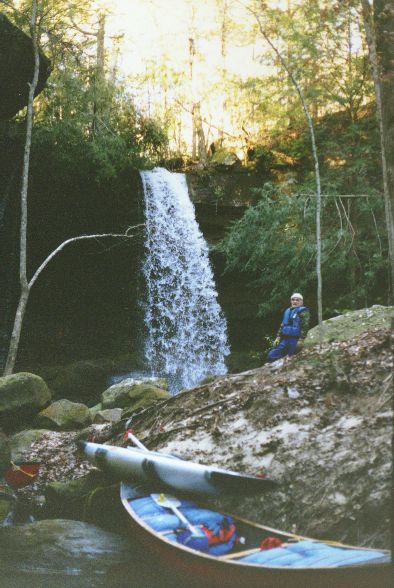
The Sipsey River is Alabama's only "Wild and Scenic" designated river. This run is entirely within the Bankhead National Forest located in north Alabama. The river is generally runnable throughout the winter months and into the early spring. Runnable levels on the Sipsey occur only sporadically during the summer and fall months.
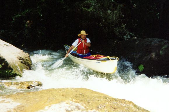
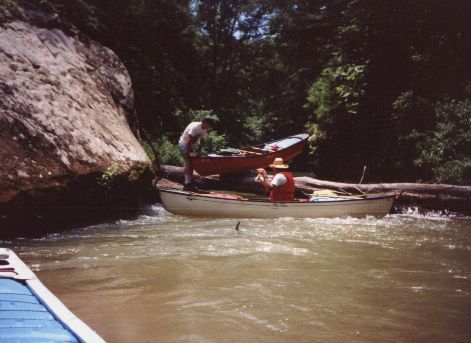
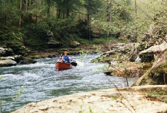
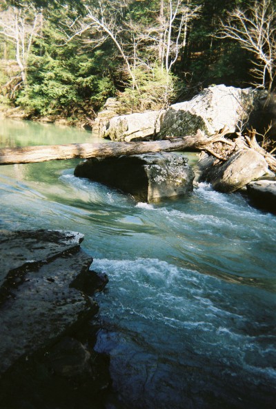
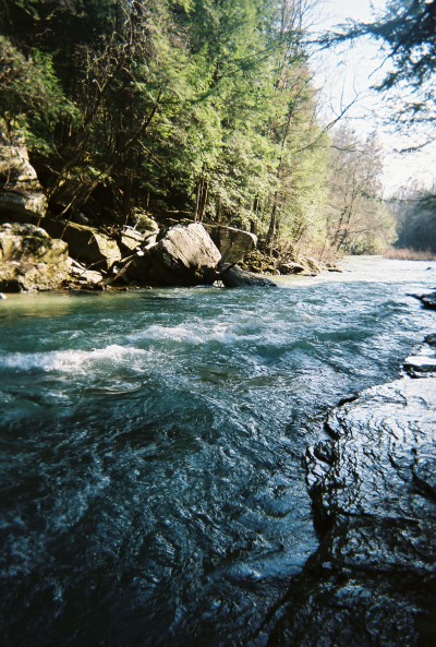
The put-in is at the Sipsey Recreation Area on County Road 60. The recreation area has a large paved parking lot, picnic tables, restrooms and a sloping ramp, making it one of the most convenient river launching sites in the state. The river downstream of the launch site is a combination of vertical canyon walls and steep hillsides. The flow of the steam is continuous and the water color ranges from clear to deep turquoise in the pools. Shoal areas appear frequently and add to the excitement for beginner canoeists. Only one actual rapid occurs at a spot where the river necks down to the right. There is actually very little drop across the rapid, but standing waves form at the bottom and give a bouncy ride. At high water levels the standing waves will increase in size. There is a boulder in the center of the rapid which has wrapped several canoes. [Some call this rapid 100 yard dash].
As of August 2009, there were no strainers that required maneuvering or that had to portaged when the flow was about 120cfs.
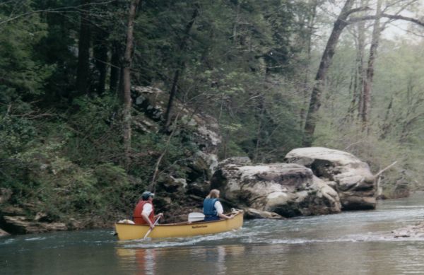
The river runs through continuously forested areas for 8.8 miles to the first possible takeout on the left side of the river. The takeout area can be recognized by the remains of a low water bridge structure. This takeout area can be accessed by taking F. S. Road 234 east off of State Highway 33. Another takeout area occurs about 3/4 of a mile downstream at the Highway 33 Bridge. The river below Highway 33 offers more outstanding scenery, but the flow of the stream is halted by the impounded waters of Smith Lake.
Canoe camping opportunities on the Sipsey are the best in Alabama. Most of the land along the river banks is a part of the national forest where there are no restrictions on camping (except during gun deer hunt dates on the Wildlife Management Area). A small portion of the land along the river is private. The only problem that you will have is making a decision on which picturesque camp site to choose. (Murray Carroll)
Details
-
ClassI (II)
-
Gradient (fpm)~3'/mile
-
Length (mi)9.5
-
Watershed Size (mi2)91.4
-
Put InCR 60 (Cranal Rd.)
-
Take OutHighway 33
-
ShuttleCR60 (Cranal Rd) /Hwy 33
-
Water Quality
 (
1 chicken | 1 = Good, 3 = Gross)
(
1 chicken | 1 = Good, 3 = Gross)
-
Primary Gage
- Sipsey Fork near Grayson 9'' wood gage, ~75 cfs?? (see below)
-
Indicator Gage
-
Precip. Gage
Map
Video
Photos


Trip Reports
Sipsey River, West Fork
April 29, 2017
By Pat W - Columbus, MS
First time Kayaking/Canoeing the Sipsey from CR60 to Hwy 33. The night prior the USGS website (Sipsey River at Grayson) was reporting 118 cfs. Based upon the information given the minimum flow is approximately 75 cfs so went ahead and planned a trip with four others for the following morning. Rechecked the flow in the morning and it had dropped to 102 cfs so we knew it might be a little slow. Since we had a novice with us we decided that the low flow would be OK. Arrived early and left a vehicle at the Hwy 33 bridge. There is a very nice gravel parking lot at the Hwy 33 pull out location that can easily fit 10 or more vehicles. There were already 6 trucks in the parking area. The parking area is located approximately 250’ from the river and has about a 50’ climb. There is a poorly maintained road that leads down to the river but you would need a four wheel drive with a high clearance to use it. The parking lot at the put in location presents no problems and is next to the river. We put in at approximately 1100. The level looked OK but unfortunately I didn’t see the wooden gage to give a good report. We had three kayaks and and two people in a canoe and did not drag except when the lead kayak choose the wrong path. The lead kayak would then direct the following kayakers on which was the best way to go and none of them dragged. At no point did anyone need to get out of their canoes due to portage or due to dragging. The scenery was beautiful and there was approximately 8 semi-rapids that made the trip a little exciting. The best was the 100-yard dash. If the flow was above 200 I imagine most of these small rapids would be quite exciting. The 100-yard dash is approximately 2/3 of the way and we met about six other kayakers there. IF you don’t mind carrying your kayak you could do the 100-yard dash many times. Following the 100-yard dash you will see some very nice overhanging cliffs that by their selves make the trip. Despite additional small streams feeding the Sipsey, the first time the lead canoe dragged was after the 100-yard dash. According to the website you can pull out your canoes short of Hwy 33 at FS234 I observed no signs of anyone using this take out location and FS234 was barricaded a half mile away at Hwy 33. I would not recommend planning on using this as a place to take out your kayaks. Within 100 meters of passing the Hwy 33 bridge you will be out the take out location. We actually missed it because the foliage had hid the path. I recommend you look behind you due to the angle of the path which makes it easier to see if you are looking upriver. We arrived at the take out at 1600. So approximately 5 hours on the river with minimal breaks. We rechecked the USGS flow as soon as we got cell phone coverage and found out that the flow had dropped to 90.2 cfs. So the approximately 75 cfs on the website is pretty accurate. Personally I would probably not start the trip if it is below 90 cfs because it appears to drop relatively quickly and you might be dragging towards the bottom of the run. Of course if their has been recent rains then it may actually rise while you are kayaking. Overall, excellent trip for a beginner due to no portages, no dragging, and enough obstructions or rapids to make it fun. If flow exceeds 200 cfs you might want to leave the beginners at home.
July 27-28, 2001
By Carl Wilson - Oxford, AL
First trip to the Sipsey. Beautiful country. Towering bluffs on both sides of the river. Arrived at about 11 am and the water level on the gauge on the bridge marker was at 6". The USGS water gauge showed 3.05 ft. Decided to go on and try it anyway after driving 3 hours to get there. Put in at 12:15 and set out. I recommend a water level at the bridge 1 ft min. At level of 6" be ready to drag your boat about 75% of the time. Our intentions were to paddle to Hurricane creek (about half way to highway 33) and camp on the rivers edge. On arrival to Hurricane creek we decided to make a run for the truck at highway 33 or get as far down the river as we could. We made Caney Creek at about 6:30 and decided to set up camp before dark. The next morning broke camp and continued on. Same thing to the take out. No water. If you could catch the water between 2 and 3 feet this run would be a hoot. Great one day trip. One section at about mile 6 called the 100 yard dash would be a good class II run at about 2 to 3 ft. Lots of undercut bluffs to paddle under. Saw 3 cotton mouths and a Blue Heron. I would definitely recommend this trip for any level paddler. Just needed more water. We talked to a Forest Ranger and he said that in case of rain the water level will rise and fall quickly.