Duck River
-
RunDuck River
-
ClassI-II
-
Put InTanner Bridge CR 1651
-
Take OutCR 703
-
Length (mi)9.5
-
Gradient (fpm)19.5'/mile
-
Watershed (mi2)30.3
-
Primary Gage
-
Indicator Gage
none
Description
Note: this run has likely been inundated by the Duck River Resevoir, a dam project which was finished in 2015. It has been left on the site for reference.
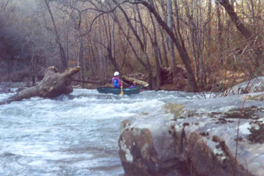
Murray thinks this is the best non-intimidating, low gradient, class II in the state, so it must be pretty good. A level of around 5.3' would be optimum, but 4.8' was adequate for a tandem boat.
Renee Clark on the section above 278: This Duck is all class I and II. There are several possible put-ins and take-outs. The run is pretty consistent from two bridges upstream of 278 (CR 1669) to two bridges downstream of 278 (CR 703). The first section from CR 1669 to CR 1651 has the least gradient, so the best run is probably from CR 1651 to CR 703 for a total of about 6.2 miles.
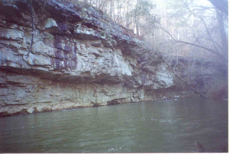
The river has a fairly narrow stream bed, about the size of the Cartecay in Georgia. It is scenic with nice sized bluffs along the banks. At 4.7' on the internet gage it has good current. There are several logjams which can be negotiated. This run would be suitable for beginners. -
When we ran the section below 278, we did not have to portage. This section is also nice I and II, but in general is less fun than Mulberry 67-278. It would however be a good change of pace for those who want some II, it has its own gage, and runs fairly often. You could run a tad lower than 4.5', but needless scraping would result. Surprisingly little civilization imposes itself on this section except for the bridge at CR 78, which is an alternate access. The take-out at CR 703 is not easy, by the way. If you put in or take-out at Hwy 278, there is good access a few feet east of the bridge on the north side of the road. You could certainly run farther down to CR 91 or beyond, but it looks like the gradient down there is pretty minimal.
This run may be dammed in the future. In fact, that is the only reason for the USGS gage, which currently is intended to give an idea how fast the water comes up after rains. The above dam website seems to give the indication that the dam is a done deal. I'm not sure if this is true since a lawsuit is in the courts. The dam would be above the section described, so its impact would be to decrease flows unless it spills. Amusingly, there are something like 200+ chicken houses in the Duck watershed, and it is a 'threatened' stream or something, yet they are building a drinking water lake/dam on it. Hmmm......
Details
-
ClassI-II
-
Gradient (fpm)19.5'/mile
-
Length (mi)9.5
-
Watershed Size (mi2)30.3
-
Put InTanner Bridge CR 1651
-
Take OutCR 703
-
ShuttleCR1669/ SR91/ CR703
-
Water Quality
 (
3 chickens | 1 = Good, 3 = Gross)
(
3 chickens | 1 = Good, 3 = Gross)
-
Primary Gage
-
Indicator Gage
-
Precip. Gage
Map
Video
Photos

Trip Reports
Duck River
February 2001
Written by Renee Clark
Even though we put on late for a winter run (around 12:30), the 6 miles was easy to make before dark. The river has a fairly narrow stream bed, about the size of the Cartecay in Georgia, with nice sized bluffs along the banks. It was very scenic, with good current. The only problem was several logjams; but we were able to get thru all, even though it was tight in places. It might have been more difficult for large canoes, but it still could be done. The rapids are class I-II, and at this level a little boney. The put-in and take-out are both fairly easy for any type of boat. This run would be suitable for beginners and up.
THE BEST CLASS II TRIP IN ALABAMA AND I CAN GUARANTEE THAT YOU HAVEN’T PADDLED IT YET!
December, Long Ago
Written by Murray Carroll
Yes, I know that’s an awfully big statement to make in this esteemed journal that equates to the gospel for north Alabama paddlers, but I believe that we have all overlooked the best Class II in the state. Several years ago, Mark D’ made a first HCC trip down the “Upper, Upper, Upper Mulberry” (Highway 67 to U.S. Highway 278) and since then it has become a favorite of Huntsville boaters who don’t like the steeper style of creek. In fact I’m also fond of that run, but I believe now that we have found a creek in the same neighborhood that has much more whitewater but doesn’t intimidate beginning paddlers.
After a long hiatus from boating brought about by a combination of a heart attack, starting a weekend business and my weakness for bass fishing, I decided to take advantage of this extremely wet early winter and lead a trip. I watched the river levels for about two weeks and decided to give the Duck River between Cullman and Arab a shot. Mark D’ had the run listed in his Alabama Whitewater paddling guide, but he and Dave Curry had only ran a section of the river south of U.S. Highway 278. He had photos and a brief description of the run above Hwy. 278 based on reports from Birmingham paddlers. Mark advised that he was not impressed with the section that he had paddled and thought that we should try the section from County Road 1669 to Hwy. 278. The level was 4.8 feet on the gauge and the time had come to make this trip.
I was able to recruit a small crew to make this first HCC descent of this section on the Sunday following the HCC Christmas Party. The brave souls all were paddling open canoes and included Bob and Brenda Barnett, Chris Phillips, Brenda Collins, Orrin Long, Kay and myself. The put-in at County Road 1669 has parking for about 4 cars and the access is fairly easy. The run down to an intermediate bridge at County Road 1651 could best be described as nearly continuous shoals with good moving water between the closely spaced shoals. At County Road 1651 the topography changed dramatically and steep bluffs began to line the river. From County Road 1651 to U.S. Hwy.278 the river features gave way to more actual drops and light rapids mixed with some shoals. I couldn’t guess how many shoals and rapids are on this run, but you’re never bored nor will most paddlers be intimidated. The run passes through what appears to be total wilderness, but you know that the chicken houses must be just out of sight beyond the bluffs and trees. The run ends at the Hwy. 278 bridge take-out that’s none too easy, but is not as bad as a lot that I know of.
Beware of a few downed trees on the run; I believe that we had to portage about two or three. One of the trees was at the lower end of a blind-turn rapid and blocked the egress. Thankfully a good eddy was located just upstream of the downed timber; it saved the day for us.
Well, I’ve made the claim that this is the best Class II in the state and I’ll stand by the statement. Be sure to make the run before the Cullman dam builders start moving dirt and cutting trees.