Gurley Creek
-
RunGurley Creek
-
ClassII - III
-
Put InNarrows Rd (Dirt)
-
Take OutSR 79
-
Length (mi)3.5
-
Gradient (fpm)70, 20, 10 (1.5)
-
Watershed (mi2)20.5
-
Primary Gage
- None Visual
-
Indicator Gage
- Cahaba nr Mtn Brook 800 (rising preferred)
Description
Gurley creek goes through the Narrows of Gurley Creek Gap north of Birmingham. It flows out of a series of lakes east of SR 75 including Mountain Lake. This is a short run that can fill out a day in the Birmingham/Locust area. This creek is narrow but not nearly as skinny as one might expect. It goes to prove that with enough water, almost any creek north of Birmingham, east of Arab, and south of Huntsville can be run. The run begins with simply fun III- and III. These non-threatening, delightful rapids continue for the better part of a mile. On the way, you paddle through the remains of an old broken down railroad trestle. Few logs are in the upper part though you will have to take evasive maneuvers towards the bottom of the run. Once you are past the fun rapids, the action gets pretty darn flat but moves for the most part. A really easy front surf and 360 wave is not far above the bottom. Just upstream of the take-out is a 7' dam that can be run though it is scrapy. If the dam can be run there will be enough water for the entire run. This run is not worth it as a destination unto itself but in combination with other runs makes a sweet day.
We put-in where the road comes close to the creek on Narrows Lane. You could put-in higher up but there is little gradient. The run length listed is from the confluence with Sand Valley Creek, although it may be hard to actually put-in right there.
There may be another section with low (20'+?) gradient above the confluence with the Locust south of Trafford...
Renee Clark has a few words of caution:
Has anyone had trouble with the landowner on river left at the dam? We were there Saturday (1/26/02) and right after I took out on river right, a woman came running to the bank on river left yelling at the two paddlers in their boats. They were boat scouting the dam, but did not plan to run it. At first I thought she was trying to warn them not to run the dam, but then she got louder yelling about private property and get out immediately, pointing (actually waving madly) across the river. She then yelled that she was calling the cops and left when the boaters got out. We walked up the dead-end road to hwy 79, where we were parked. We saw her drive by, turn around and drive back by and then go back home. Anyway, it was unnerving. We had not planned on getting out on river left, but had observed when we parked that there was a church parking lot that we considered, which would have been on river left. That would have put us taking out on her property or having to walk down hwy 79 from river right to get to the car. Anyway, if you paddle there, watch out for her. She's got some real anger inside.
Editors note: I believe the case to be in Alabama, as it is in most states, that if you can legally access a run at the put-in and take-out, you can legally make the run. You can portage or scout up to the high water mark. No irate property owner wants to hear this, but I find it comforting in times of seemingly impending legal action.
Details
-
ClassII - III
-
Gradient (fpm)70, 20, 10 (1.5)
-
Length (mi)3.5
-
Watershed Size (mi2)20.5
-
Put InNarrows Rd (Dirt)
-
Take OutSR 79
-
ShuttleNarrows / Kiowa / SR97
-
Water Quality
 (
2 chickens | 1 = Good, 3 = Gross)
(
2 chickens | 1 = Good, 3 = Gross)
-
Primary Gage
- None Visual
-
Indicator Gage
- Cahaba nr Mtn Brook 800 (rising preferred)
-
Precip. Gage
Map
Video
Photos
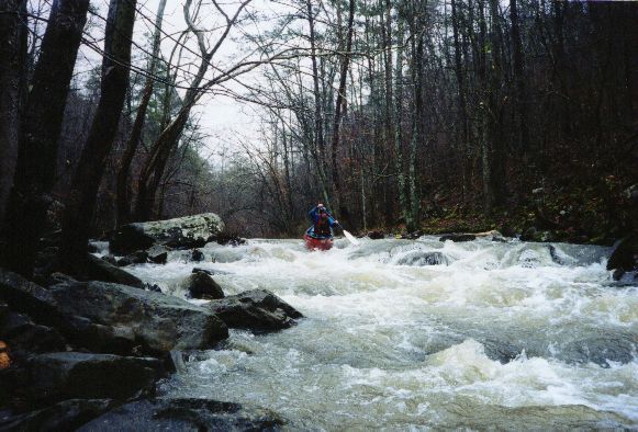
A fun easy class III
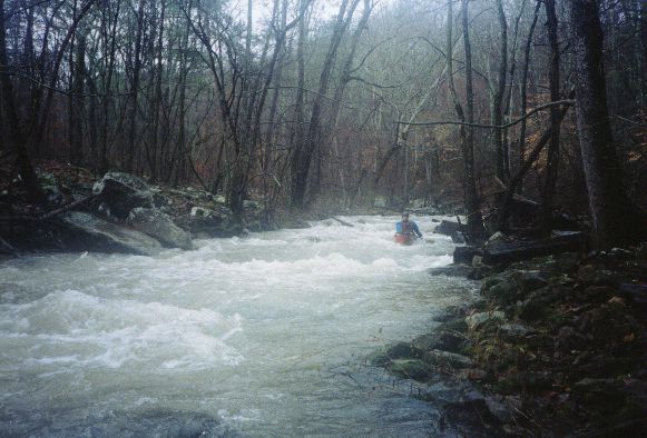
Continuous fun for awhile. Sorry about the fog.
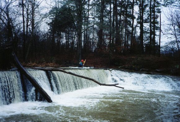
I struggled mightily for some paddle grip at the lip of the dam at the end. To no avail.
Trip Reports
Gurley Creek
March 3, Long Ago
Written by Dave Curry
The seemingly endless quest goes on. All week the rain gauges are watched, the topographic maps are studied, watersheds are outlined in the Gazetteer, put ins and take outs are carefully marked on the maps, and commitments from fellow travelers are solicited. The preparations are incredibly detailed and no stone is left unturned. Those lucky enough to get to tag along must be ready to paddle at the drop of a hat; the perfect level on the perfect stream waits for no one.
The quest has uncovered some gems, but we have also had our share of "burns, busts, bummers and rip-offs." The careful planning has sometimes produced a trip to a creek with too little water, a five-hour drive to a flat-water creek with one rapid, or a seemingly never-ending series of portages through impenetrable briar patches. The bad trips don't by any means mean the quest is not worthwhile, it just means that the "strap hangers" have to put up with some disappointment for the privilege of being part of the occasional "first descent" of a pristine creek somewhere out in the hinterlands.
Ironically, on March 3, Mark and I uncovered a gem by accident. We were on our way to what turned out to be a boring five-mile near flat-water paddle on the Upper Cahaba when we both noticed Gurley Creek, a small creek that crossed under Highway 79 near Massey Line; for those who don't know where that is, it's close to Remlap. Mark carefully studied the Gazetteer while driving at 65 miles per hour down a congested two-lane road and determined it had some potential. While we paddled the Cahaba, we discussed a possible second run of the day. We didn't dawdle; after a quick, but mostly boring paddle, we packed the boats onto my car and headed straight for Gurley Creek.
We were not disappointed. Gurley Creek proved to have about two miles of near nonstop Class III whitewater. At the end of the whitewater section was a near perfect river-wide 1½ foot wave that even I could surf for hours. We did have about one mile of flat-water to paddle to the take out, but near the end was an eight-foot dam that Mark just had to run. The water on top of the dam was very shallow; he scraped, got slowed down and made a Dave Branham "pencil point entry." A second attempt produced the same results.
For those willing to take the challenge and become part of the quest, there are some important rules that must be adhered to. These are:
- Departure time is early: 7:00AM is good, 6:30AM is preferred.
- Return time is always unknown. If you are going to the symphony that night, be prepared to go without showering and maybe even miss the overture.
- Check the put in and take out points carefully. It would be bad to paddle all the way to the Gulf of Mexico looking for the take out because you misread the map and put on the wrong creek.
- Be prepared to get mud on and in your car and all over yourself.
- Be willing to help tow cars out of the mud.
- Be willing to drag boats through endless briar patches.
- Be prepared to wear a dry suit all day long. Multiple runs in a day are mandatory and there is no time to be wasted on changing clothes.
- Don't be squeamish about putting onto a creek right next to a sewer plant or hog farm.
- Take a boat that you are willing to get scratched up a bit. Some of these creeks can be really destructive on your hardware.
- If there is rain in the area, be prepared to hit the road at the drop of a hat. The "good stuff" waits for no man.
- When on the creek, be ready for anything. There is no telling what might be around the next bend: It could be a waterfall, a 500 yard long Class IV rapid, the church of Mother Angelica, or just a massive garbage dump.
There are those who say the quest is fruitless, that all the good stuff has been discovered and already run. I, for one, find it to have at least some hidden vestiges of nobility, and, like the Holy Grail, the undiscovered perfect creek may still be out there.