Johnnies Creek Upper
-
RunJohnnies Creek
-
ClassIII-IV or II (III)
-
Put InHwy 176 or CR47
-
Take OutCanyon Rim Road (CR 275)
-
Length (mi)6.1 or 2
-
Gradient (fpm)100, 95 (0.73), 1.9 mi. lake, 5 (0.5 to CR47),10, 40
-
Watershed (mi2)6.4
-
Primary Gage
- StreamBeam Johnnies Creek -0.15'
- CR 275 Bridge -2"
-
Indicator Gage
- LRC 2000
Description
With thanks for lots of help from Brad Roberts and RangerRob:
There are two upper sections of Johnnies Creek. The first part is a short III-IV gorge followed by a lake. The second is class II (III). When Johnnies is getting high, this is a fun alternate run if for some reason you don't want Bear or Wolf or the big bad Wolf (did someone mention Chinquapin? I didn't think so)
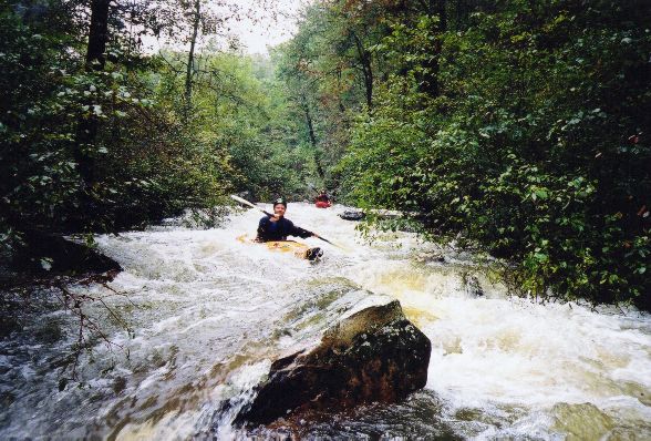
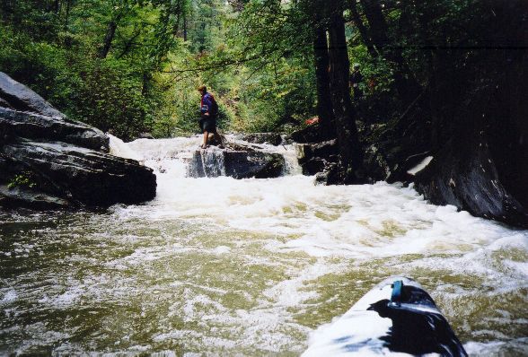
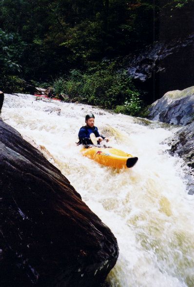
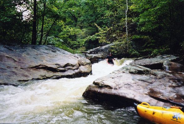
The top section quickly drops into a class III-IV gorge that is continuous and nicely technical. A little tougher than "Teddy" Bear Creek. There are a number of tight rapids, a few of which need scouting. One drop has a slot that feeds left to an undercut wall, another has a large slab rock in the middle of the river. This section is very nice at 4" on the new river right gage at the 'normal' run put-in. This run is tight and at a good level demands a quick move or two. One rapid towards the end of the steep section is called "In Memory Of #3". The rapid consists of a creek wide boulder pile/ledge drop of about 5 feet. 6 feet from the base of the drop is a semi-truck size slab wall of a boulder that is almost river wide - starting from river right. The right side of this boulder harbors a sieve, similar to Fist on the Russell Fork. The only way to run it at low water is hard left, with a strong boof then an immediate correction to the left, in order to avoid pitoning into the boulder. The boulder does not appear to be undercut, other than the sieve on the right. At higher water it opens up enough to hit a clean though tricky right to left line off the boof.
In the midst of the top section is 1.9 mile long Lake Lickskillet, which makes this section a bit less appealing than it otherwise might be. At the end is an earthen dam with a concrete slide. The slide is runnable. It's about 30 feet high and about 50 feet long. It is wide and the concrete is rough, so you don't go any faster then about 3 miles per hour between -2" and 4". We do have a landowner issue here. The landowner near or of the dam was pretty peeved when a group of 7 folks were scouting and running it recently. Since the creek can be legally accessed at Hwy 176 and multiple points downstream, it is legal to run. However, I'm not sure about the dam itself. In the future, the best course of action may be low key expeditious portage. After the dam is class I until the CR47 bridge.
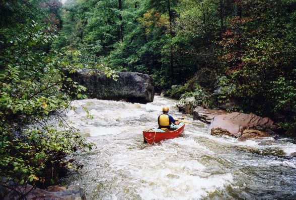
The stretch of Johnnies from CR47 to CR275 is a pretty little gorge. Mostly flatwater, but the last mile has a few good class III drops. This would be a good, short, up and coming beginner run. You do have to walk around one tree as of late 2002. After a while you come to a 6 inch ledge, then a one foot tall ledge, and they keep on growing. Toward the end there are two or three Nantahala Falls type drops. Overall this section is mostly class II with one or two class III's. Most of the stuff below the dam is small wave train and rock avoidance. The few class III's are actually II+ or III- at low water, but are solid III at 4" or so. The creek is very narrow and will pick up the occasional strainer from time to time. Take-out at the usual run put-in just above or below the falls.
The gage for this run is on the CR275 bridge. On the river right bridge support, -2" is about minimum, while 4" is a good level.
Details
-
ClassIII-IV or II (III)
-
Gradient (fpm)100, 95 (0.73), 1.9 mi. lake, 5 (0.5 to CR47),10, 40
-
Length (mi)6.1 or 2
-
Watershed Size (mi2)6.4
-
Put InHwy 176 or CR47
-
Take OutCanyon Rim Road (CR 275)
-
ShuttleCR47 / CR43 / CR275
-
Water Quality
 (
2 chickens | 1 = Good, 3 = Gross)
(
2 chickens | 1 = Good, 3 = Gross)
-
Primary Gage
- StreamBeam Johnnies Creek -0.15'
- CR 275 Bridge -2"
-
Indicator Gage
- LRC 2000
-
Precip. Gage
Map
Video
Photos
The beginning of the upper part gets intimate with the trees on the bank, which crowd and overhang the stream.

Here you have a choice between the overhanging tree and the side of a tree.
Heading to the right of a big rock in the middle of the stream bed.
This was the most difficult rapid at about 4" on the river right CR275 gage. A good lean as you deflected off the boulder the water slams into is (...)
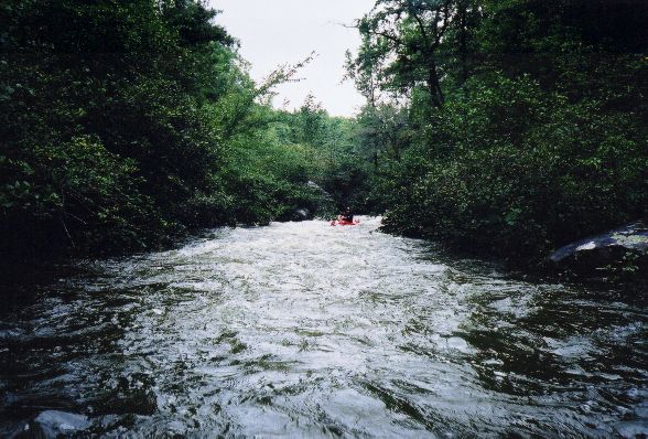
A neat funnel rapid, which was immediately followed by a strainer. Ropes and a strict no-swim policy are wise here.
A tight but easy spot.
This is below the CR47 bridge. Mellow and once again tree-rich.
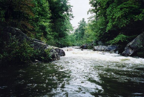
The best class III just above the CR275 bridge on 'lower' upper Johnnies.
Trip Reports
Johnnies Creek, Upper
May 4, 2002
Written by Ranger Rob
If you look at AW's description of upper Johnnies Creek in Little River Canyon in AL, it describes it as a 6 mile, 2-3 run that starts off at Hwy 176. This description is very innacurate! The class 2-3 section is from the first bridge upstream to the regular put-in for the canyon run. If you put-in on HWY 176 you'll find a very different run then is described in AW's web site.
Last Saturday, I took a group to run "something" in AL. We finally ended up at LRC @ 3.5'. I decided to check the creeks. Johnnies was at -2", so I decided to check out the upper section, since the group wasn't as strong as I'd like to run regular Johnnies. We put in on the first crossing of Johnnies Creek's headwaters on HWY 176. (I now refer to this as the Upper Upper Put-In) The creek, very quickly, drops into a class 3 - 4 gorge that was very continuous and nicely technical. A little tougher then "Teddy" Bear Creek. One rapid of note, we named "In Memory Of #3" -- for all you race fans.
The rapid was a creek wide boulder pile/ledge drop that dropped about 5 feet. 6 feet from the base of the drop was a semi-truck size lab wall of a boulder that was almost river wide - starting from river right. The right side of this boulder had a sieve, similar to Fist on the Russell Fork. The only way to run it was hard left, with a strong boof then an immediate correction to the left, in order to avoid pitoning into the boulder. The boulder didn't appear to be undercut, other then the sieve on the right. A few who ran it had to brace off the wall and the current pushed them out to the pool below.
At a certain point the gradient eased and we -- believe it or not -- found a lake in the middle of Johnnies creek!!! Yes it is an honest lake. It's Lake Lick Skillet and has been there for 20 years. I think it's a private lake, and all roads leading to the lake are private. The owners didn't seem to mind us paddling across the lake and didn't seem to have a problem knowing we were going to portage and/or run the dam. Lick Skillet lake has yet to be put on any topos (not true -editor). Its about a two mile paddle from the creek to the dam.
The dam is 1/2 earthen levey and 1/2 slide to keep the lake level consistent. Its about 30 feet high and the slide is about 50 feet long. You'd assume it would have an "Oceana" effect when running it, but the concrete was rough, so you don't go any faster then about 3 miles per hour.
After that Johnnies is the class 2-3 that AW mentions and we came to the first bridge upstream of the regular put-in. From there, it continues to be mostly class 2 with one or two class 3's. Most of the stuff below the dam is small wave train and rock avoidance. The few class III's are actually II+ or III-. The creek is very narrow and I'm sure would pick up the occasional stainer from time to time.
We did this when Johnnies was -2", I'd consiter this to be a bare minimum. Remember, the gauge on Johnnies is marked in 2 inch increments! I'd suggest a +2" would be a good low. So, when Johnnies is getting high, this would be a great alternate run!!!