West Fork Little River Lower
-
RunWest Fork Little River
-
ClassIII (IV)
-
Put InCloudmont or Lake Howard/CR 165
-
Take OutForest Road 04 or Rt. 35
-
Length (mi)6, 9, or 12
-
Gradient (fpm)30'/mile (3 miles), 38'/mile (4 miles)
-
Watershed (mi2)40.3
-
Primary Gage
- Little River near Blue Pond 1000 cfs
-
Indicator Gage
none
Description
A seldom made run that is all class II and III except for the optional put-in rapid and one III+ with an undercut. It gets basically dry in the summer so brush and trees encroach on the streambed. Few signs of man are seen along this run, and it is beautiful on a sunny day. Unfortunately, it takes a good rain to get it going and can involve a fairly substantial paddle out on flat water and shoals (it may not be too bad - see map in gallery and text below). It sports quite a few good surfing waves and holes for it's size.
Most folks put-in at Lake Howard, but you can add three more miles by putting in near Cloudmont. I've never run this upper part and there appears to be minimal gradient. The optional rapid at the Lake Howard Dam is a multi-drop IV that is easily scouted or walked on river right. Just after that, two tight and fun rapids will make sure you are fully awake. Good class III stuff continues on and off until you get to Broken Nose. It will be semi-obvious, stay right to scout or run - the left drop will take you into the undercut (see pictures). Overall, comparable to the middle Tellico or a bit easier. As of 2/04, there are very few logs, and the few there are can be easily avoided at 250 cfs. At 250 cfs, it took us 15 minutes to paddle the flatwater at the bottom of the west fork, 20 minutes to get to Road 03, and an hour more to get to the 35 bridge. There are some sweet waves in the last two miles above the 35 bridge.
Multiple put-in and take outs are available. It is 3 miles from Cloudmont to Lake Howard, 4 miles from there to the confluence with the East Fork, then three miles to a river left forest road take-out (road 04). Road 05 would be the best take-out on river right, while Road 03 would be the best takeout on river left. Road 03 is rutted, but not too bad in a pick-up, or anything with ground clearance (I've heard 05 can be a quagmire at times, but check it out and let me know). 4WD may be needed on some of the hills if it has rained recently. See the access map in gallery. Three or four more miles bring you to route 35 upstream of the falls. The river below the confluence is largely flat. The alternate take-out about 3 miles below the confluence avoids some flatwater, but delivers a long shuttle. To get to the alternate take-out in 1997, you took Crest Rd. north off Rt. 35 (east of Little River), drove about 3.4 miles and then turned left on forest road 02. After following 02 for 1.4 miles, turn right on road 04 and you'll be at the river.
Details
-
ClassIII (IV)
-
Gradient (fpm)30'/mile (3 miles), 38'/mile (4 miles)
-
Length (mi)6, 9, or 12
-
Watershed Size (mi2)40.3
-
Put InCloudmont or Lake Howard/CR 165
-
Take OutForest Road 04 or Rt. 35
-
ShuttleCR 165 / CR 89 / Rt. 35
-
Water Quality
 (
1 chicken | 1 = Good, 3 = Gross)
(
1 chicken | 1 = Good, 3 = Gross)
-
Primary Gage
- Little River near Blue Pond 1000 cfs
-
Indicator Gage
-
Precip. Gage
Map
Video
Photos


Trip Reports
West Fork Rediscovered
March 21, 1997
Written by Mark D'Agostino
“There is nothing new under the sun” Some of us just haven’t made the run yet.
- If local class III exists that I’ve never run before, I have got to do it.
- Too many times each spring the HCC blindly heads out to the Locust or Mulberry when other Class II or III options may be available right next door. So...
On Saturday, March 21, 1997, a group of paddlers including Dave Curry, Mark D’Agostino (OC-1), Gary Holder (C-1), Greg Hunt (K-1), and Trouble (D-1), ran the West Fork of the Little River, AL. This may have been the first HCC trip down this section of river since the mid to late 1980’s. None of us had run it before. We have Hal Scofield and Mike Abernathy to thank for maps and river information. I had been wanting to make this run for some time. We were not disappointed.
We put in at the bridge over Lake Howard. It is just upstream of the DeSoto State Park, about 5 miles north of Rt. 35 just off Rt. 89. We took out on river left about 3 miles downstream of the confluence of the East and West Forks (ask one of us or Hal for directions). Shuttle took about 1 hour round trip. There is a much better place to take out shuttle- and flatwater-wise on river right just downstream of the confluence, but we have not yet found out how to get there. The Rt. 35 bridge gage was at 6”, which proved low but runnable. Any lower would have been scrapy.
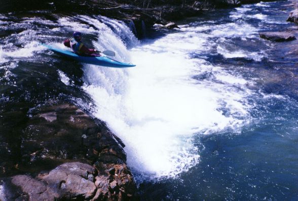
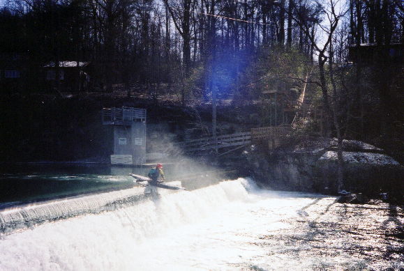
The normal thing to do would be to paddle down the lake 150 yards, then portage around the dam and subsequent class IV rapid. Since Greg and I are abnormal, we both ran the dam and the following 10’ waterfall. Greg then ran the rest of the rapid, but I portaged the last drop after deciding I probably would have problems with the required boof and that I liked my face the way it was. A man has got to know his limitations. Dams are not usually on the thinking paddlers menu but the hydraulic was minor since the dam was about 10’ high and it only had a few inches of water going over it. Greg said it would be a prime New York rapid. I don’t recommend the straight (not very flat landing) run that I chose. I tried to maximize speed, but instead maximized pain to both my boat and my ribcage as I came to a full and complete stop after striking the rocks lurking a mere 2 feet below the surface. I can’t really complain since Greg had warned me of how shallow it was. Perhaps a 45 degree angle or a walk would have been better.
The river starts right out from there at around 38’/mile for 4 miles. It is drop/pool in nature, requires some eddy catching and ferrying skill, but is not too difficult. I would say it is definitely easier than Town Creek, perhaps slightly easier than the Middle Tellico, significantly harder than the Locust. One rapid (they may have called it Broken Nose - real imaginative) may rate an easy IV but is really a III with consequences (IIIE).
Dave had to execute the first of many bush braces on the initial rapid. When one particular branch opted to poke him in the neck, he jumped in the water in retaliation. Since Greg, Gary, and Trouble seemed to have the situation well in hand (Gary is a former safety director, you know), I chose to surf the glassy wave at the top of the rapid while thinking sympathetic thoughts of Dave. Indeed this was the first of several nice waves throughout the run. At one point, Greg and I did our part to provide a photo op for a crowd of hikers by simultaneously front surfing (me) and doing 360’s (Greg) on the same wave.
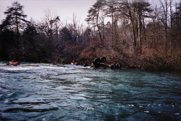
We stopped for lunch at what was known as the ‘easy’ class IV (Broken Nose?). If we start doing this run more often the rapid will have to be renamed. I can’t stand repeated or boring names. Anyway, at this level it is really a class III double drop with an easily avoided or accessed (depending on where you are) undercut on river left. At this water level, if you run it right, the rapid is not a problem. However, should you run it left as Greg did, you may end up repeating his in-situ inspection of the entrance to the undercut. He and boat eventually emerged unscathed, but not before providing ample anxious moments for all. At higher water I suspect a larger hole develops on river right, but the line against the bank would most likely remain the same.
On the not so upside, there was about 0.5 miles of flatwater before reaching the confluence. There was also a log that had to be portaged by the open boats, but it could be seen from a good distance upstream. The sometimes moving 3 miles of flatwater after the confluence was not that bad and would be better with more water. It could be real bad with a south wind. Most of this would be avoided with the better take out.
All in all it was a fun class III trip with beautiful water quality, weather, and a relatively short ride home. For those who seek an alternative to the standard runs and a step up from the Locust, it is well worth a try. It does require a fair bit of rain, so it will be a wet season trip. Next to try the East Fork! (By the way, D-1 stands for solo dog)