Short Creek Upper
-
RunShort Creek
-
ClassII-III
-
Put InRt 75
-
Take OutCR 409 (Martling Rd.)
-
Length (mi)1.4
-
Gradient (fpm)20, 20
-
Watershed (mi2)85
-
Primary Gage
- StreamBeam Short Creek 0.75'
-
Indicator Gage
none
Description
What used to be a 4.4 mile easy introductory creek has been hamstrung by access issues at the takeout. No parking signs have been put up by the county on Hustleville Rd. (CR 414) on both sides of the bridge, per the landowners' request. This leaves Martling Rd. (CR 409) as the only plausible access point below the upper put-in on AL 75, with only 1.4 miles between the two. Most of the action in the upper section was below Martling Rd., so only flatwater and class II remain in the modified upper stretch.
It may still be worth putting in at AL 75 to extend a day on Lower Short.
And now, here is a "classic" HCC run description by Ron Paulus, Hal Scofield, Clay Spencer, and John Watts. We owe a debt of gratitude to the folks who were doing stuff we now take for granted long before a lot of us knew what whitewater was.
Short Creek is located in Marshall County and is covered by the Albertville topo. The run described here is from the Alabama 75 bridge, 2.7 miles east of Albertville, downstream 4.5 river miles to Short Creek Falls. This report was written from a run made 2/15/82 by Paulus, Scofield, Spencer and Watts. No known river guide covers this run.
To reach Short Creek Falls, take Alabama 227 northeast from Guntersville. After crossing an arm of Guntersville Lake and a railroad, go 1.9 miles and turn right on County 441. Go 4.0 miles to the bridge, turning left at two Y's. You may not notice either Y, just stay on the main road. To reach the put-in, proceed on 441 for 3.6 miles to Alabama 75, turn right, and go 1.1 miles to the bridge.
The overall gradient is 23 feet per mile, and the maximum is 38. There are three solid Class III rapids, all located in the last two miles of the run. Other rapids are Class I or straightforward Class II. The run is suitable for intermediates in either decked or open boats.
(editor: the gage is now on the older Rt 75 bridge) There is no streamgauge; however, water level about an inch below the top of the concrete pad supporting the bridge piling on the northeast side of Alabama 75 bridge indicates runnable flow. At this level on a warm day the last two miles of the run rate 17 points, Class III. The second Class III rapid rates 20 points.
The first half mile or so has only a few riffles, then Class II rapids appear. They are simple and short, generally consisting of chutes through a single line of rocks. None has a big drop or large waves. There are holes to play and good eddy turn practice. After an intermediate bridge (the usual put-in for lower Short these days), the relatively flat gradient continues for perhaps a mile.
The gradient then increases to 38; however, the river does not change appearance except at the Class III rapids. There the drop is sufficient to cause the increased gradient. The first two of these rapids remind one of Town Creek Canyon. They are long and require Class III maneuvering. The last rapid on the run is short but has a drop of 4 or 5 feet. The entire river goes through a chute and over a big rock at the bottom of it. The rock has a strong pillow which tends to push you off of it.
The difficult takeout is on the right (currently posted and clearcut, take-out river left and park way up the road towards Guntersville on the south side). There is no parking space at the County 441 bridge so you can carry your boat all the way out of the canyon or risk your life by parking and loading in the road. Parking space for a few cars is available along the road completely up and out of the canyon by the "no parking beyond here" signs.
Warning: Short Creek Falls, a 20 foot dead drop, is 700 feet downstream of the takeout. River gradient below Short Creek Falls reaches 180 feet per mile. (Well, maybe 100'/mile, and generally regarded as an easy 18' waterfall followed by III+ or IV- depending on level and attitude)
Details
-
ClassII-III
-
Gradient (fpm)20, 20
-
Length (mi)1.4
-
Watershed Size (mi2)85
-
Put InRt 75
-
Take OutCR 409 (Martling Rd.)
-
ShuttleRt. 75 / CR 414
-
Water Quality
 (
3 chickens | 1 = Good, 3 = Gross)
(
3 chickens | 1 = Good, 3 = Gross)
-
Primary Gage
- StreamBeam Short Creek 0.75'
-
Indicator Gage
-
Precip. Gage
Map
Video
Photos
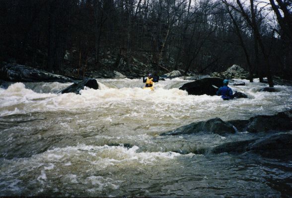
Jim Dowdy on one of the Class III's. John Parker looks on.
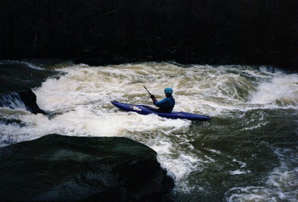
John Parker peels out in preparation to ferry above the manacing pourover hole ;-)