Hatchet Creek
-
RunHatchet Creek
-
ClassI (II)
-
Put InUS Hwy 280
-
Take OutUS Hwy 231
-
Length (mi)13
-
Gradient (fpm)14'/mile
-
Watershed (mi2)118
-
Primary Gage
-
Indicator Gage
none
Description
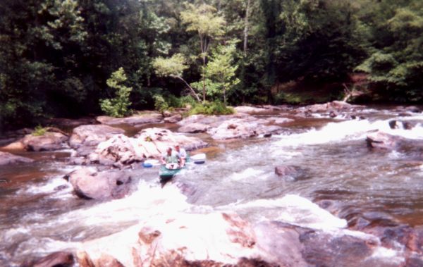
A beautiful, clear creek located south of Sylacauga. The creek's headwaters are located in the Talladega National Forest and it runs through mostly forested land until its flow is stopped by Lake Mitchell. The stream flows briskly below Highway 280. The pools are frequently interrupted by frisky shoals that add spice to the trip. The scenery is exceptional with only a few streamside cabins to remind the canoeist that you're not in total wilderness. There is one Class II+ drop on this section of creek. Maximum flow is about 2000 cfs. (Murray Carroll)
The gradient is a bit of an approximation, but fairly close. There are other sections to Hatchet, but I'm not sure they have any whitewater.
I don’t think you can correlate the 280 bridge gauge with the USGS gauge below 231. This is because you are trying to correlate two different points on a curve that varies its trajectory with increasing flow rates. Sometimes the USGS gauge says 3000cfs and 280 gauge says 3ft. Other times the USGS gauge says 1200cfs and the 280 gauge is still on 3ft? So from my years of experience with this creek, you just can’t make an accurate computation about this creek and its large watershed. Anyway 2ft 11in is a great level for beginning canoeist. At this level you have great flow all the way to the take out. All the rocks are submerged so you have nothing to avoid hitting. There is only one rapid that is a strong class II at this level. It is easily portaged on the left. You can tell you’re near the rapid by noticing the new log cabin high above the rocks on your left. Eddy out just above the rapid on your left below the cabin. The creek is floatable at lower levels (1ft6in) but I’ve had my experience dragging and dodging. This is the ideal level for any beginners. - Fletcher Scott
Finally, as of late 2010:
Maggie Johnston now owns the cabin on the hill across Talladega Creek from the Waldo Old Mill restaurant and rents it out as a guest house. This as an option for boaters who are interested in paddling Talladega Creek, Hatchet Creek or others in the area. See her VRBO site.
Details
-
ClassI (II)
-
Gradient (fpm)14'/mile
-
Length (mi)13
-
Watershed Size (mi2)118
-
Put InUS Hwy 280
-
Take OutUS Hwy 231
-
ShuttleHwy 280 / CR 49 / Hwy 231
-
Water Quality
 (
1 chicken | 1 = Good, 3 = Gross)
(
1 chicken | 1 = Good, 3 = Gross)
-
Primary Gage
-
Indicator Gage
-
Precip. Gage
Map
Video
Photos

Trip Reports
Hatchet Creek
April 25, 1998
Written by Murray Carroll
Hatchet Creek, located south of Sylacauga, Alabama, provided the perfect ending for our yearly April paddling marathon. Kay and I started the month off with an overnighter on the East Fork of the Little River, went to the Clear Fork River the next weekend, took a week off and then headed south to Hatchet the following weekend. It has really been pleasure to paddle tandem for three trips in a row; seems that we normally take the Explorer out about once a year. Joining us for the trip from the club were Bob "Ho-Ho" Barnett and Chris Barnett (OC-2), Brenda Barnett (OC-1), Soos Weber and Steve Caudill (OC-2), Louis and Rutland Price (OC-2), Brad Mclane (OC-1), Dr. Joel Cochran (K-1) and Johnathan (K-1).
Dr. Cochran, a fellow Alabama Rivers Alliance director, is a member of the Coalition for the Preservation of Hatchet Creek and served as our guide for the trip. With Joel's help, we obtained permission from a conservationist landowner to camp on the creek bank just below the Highway 231 Bridge. On Saturday we paddled the 13-mile section from U.S. Highway 280 to U.S. Highway 231. The creek runs through a remote area with no roads and only a few streams and hunting cabins. The creek reminds me a lot of Talking Rock Creek in north Georgia; lots of good scenery, many shoal areas and a couple of light Class II rapids. This run deserves more than the 7 hours that it took us to make the trip, an overnighter on this section would be great.
On Sunday we paddled the next 6.8 mile section of creek; from U.S. 231 to Kings Bridge. This section is a lot flatter than the run that we made on Saturday. The scenery was nice, but not as dramatic as the trip on the day before. The highlight of this trip is the presence of the beautiful Cahaba Lillies which bloom on several of the shoal areas. We were at least two weeks early for the lillies bloom, but we could see the plants emerging from the rocky shoals through the clear water. We departed on Sunday afternoon, leaving over 8 miles of creek to be paddled on the next trip to Hatchet. The remaining trip is a shoal studded run with some dramatic scenery which we hope to run next year. Hope that you don't miss that trip, because you sure missed a good one this year. As "Old Bob" would say "It don't get any better than this".