Little River Canyon Upper Two
-
RunLittle River Canyon
-
ClassIV (IV+)
-
Put InCurve in rim road (sign)
-
Take OutCanyon Mouth Park
-
Length (mi)2
-
Gradient (fpm)80,100
-
Watershed (mi2)145
-
Primary Gage
- Little River near Blue Pond 225 cfs (600 better)
-
Indicator Gage
none
Description
I prefer 400 cfs as minimum, but it can be run as low as 225 cfs give or take. This is really a fun part of the canyon. The Upper 2 begins just below a good surfing wave at the bottom of the Suicide section. After some warm-up, Screaming Right Turn (IV) appears immediately followed by Roadblock and Humpty-Dumpty (IV+, maybe V). I used to walk the 8' vee-hole drop that is Roadblock because I have met too many folks who almost drowned in the hole and one who did. Near death experienes are not uncommon here. Roadblock is the stickiest and most dangerous spot on any of the commonly run Alabama whitewater. Be aware of the line and consequences before you run it. H-D is a three part class IV+ or V with undercuts that gets harder at each drop. Listen for the toilets on river right. At lower levels the true ugliness of Humpty-Dumpty can be seen with a vortex flow going under the rocks on the right next to the 2nd drop and the center line on the last drop perhaps too narrow to run. Good IV fun follows on Mr. Bubbles, the Narrows, and Deep Throat. Some people take out at the top of the Chairlift section if they are getting off the Suicide, but almost anyone who puts in on the Upper 2 goes to the Canyon Mouth at the bottom of Chairlift. A put-in just below Humpty-Dumpty is also possible for the upper one run. Another take-out option exists at the Powell Trail a short distance below Bottleneck on the Chairlift section.
Another put-in option that avoids right turn, roadblock, and humpty-dumpty is the Upper 1. Here are some helpful words from Michael McCurdy: The top of the trail is just north of the Wolf Creek overlook. Coming north from the chairlift you would pass this overlook and look for a house on the left side of the road. Go no more than 75 yards past this house and park. Walk along the edge of the cliff until you find a 10 ft. drop onto a well worn trail. The sawn stump of a tree is on the left side of the bottom of this drop. This is difficult to find if you've never been there before. Jed Dugger made a good map for this put-in and I would be glad to send you a copy of it.
The tree that people used to shimmy down has been cut. You have to lower your boat down 10 feet or so to the bottom and then lower yourself on the rope. Put your throw rope around a tree (if it is at least 3/8" dia. or better) at the top and lower yourself carefully down the rock face. I'm no rock climber but this works for me. Please be careful and remember to use common sense. If you don't think you can do this, then don't. There are toeholds to put your feet in on the rockface. At the bottom of the rockface make a hard right and follow the trail along the base of the cliff until you see the white blazes of the trail leading down to the beach below Humpty Dumpty. This blazed trail makes a turn to the left at a double blaze so watch for that or you'll follow an old wash into the woods.
This is a steep and rugged trail, but it puts you in at the perfect spot to enjoy the Class III-IV boogie water below Humpty Dumpty that is above the chairlift put-in. Prudential Rock, Mr. Bubbles, and Deep Throat are the bigger rapids on the Upper 1.
The Upper 2 shuttle is a bit of a pain, and may be shorter if you go south on Rt. 176 to CR 127 and CR 275.
Details
-
ClassIV (IV+)
-
Gradient (fpm)80,100
-
Length (mi)2
-
Watershed Size (mi2)145
-
Put InCurve in rim road (sign)
-
Take OutCanyon Mouth Park
-
ShuttleRt. 176 (North) / Rt 35 / Rt. 273 / CR 275
-
Water Quality
 (
1 chicken | 1 = Good, 3 = Gross)
(
1 chicken | 1 = Good, 3 = Gross)
-
Primary Gage
- Little River near Blue Pond 225 cfs (600 better)
-
Indicator Gage
-
Precip. Gage
Map
Video
Photos
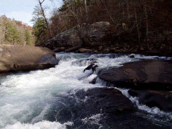
The first significant upper 2 drop, Screaming Right Turn, at a very low (hiking) water level. (Jed Dugger)
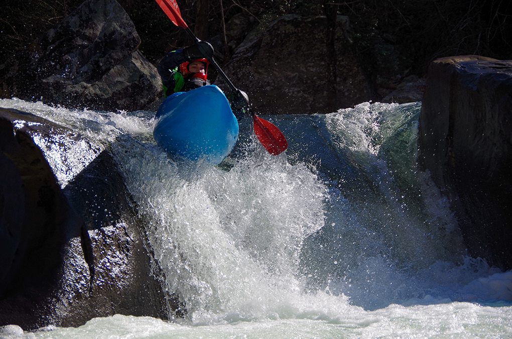
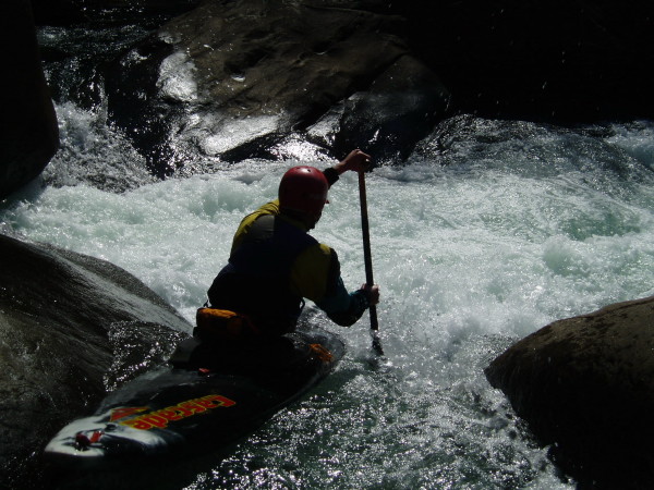
Henry Dewald executing the proper move on Roadblock. (Kellis Kincaid, January 2020)
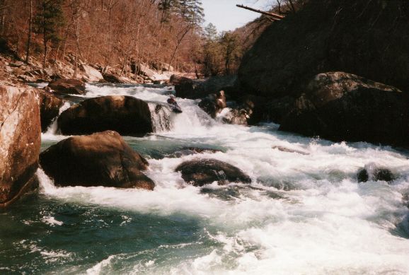
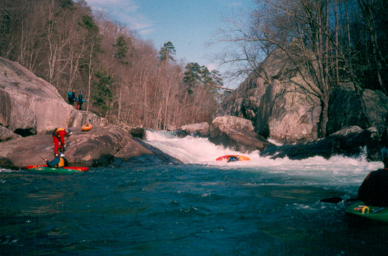
A good angle on the first two drops of Humpty-Dumpty. The big eddy on the bottom left of this picture is where most people set up for the last drop. (Sloa (...)
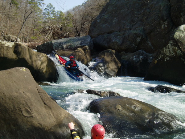
Chris Parker does the open boat thing on the main drop of Humpty Dumpty at 0" (Curt Ruffing)
Mark D' runs the right side slide of the last drop of Humpty Dumpty at about 0" (Curt Ruffing)
An unknown kayaker struggles to extricate him or herself from the hole at the bottom of Humpty-Dumpty. Many of us can say "been there, done that". Unfortu (...)

Jim Dowdy is that little speck in Deep Throat at 12"