Thompson Creek
-
RunThompson Creek
-
ClassI (III)
-
Put InNorthwest Rd (F.S. 208)
-
Take OutCranal Rd/County Road 60
-
Length (mi)8.5
-
Gradient (fpm)
-
Watershed (mi2)15.6
-
Primary Gage
- Sipsey Fork near Grayson 1.5' or 220 cfs
-
Indicator Gage
none
Description
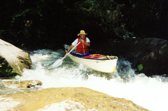
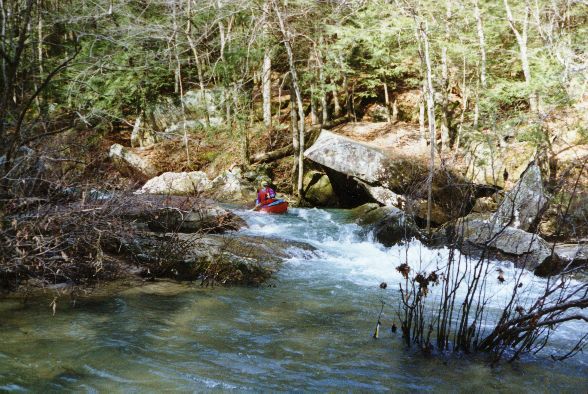
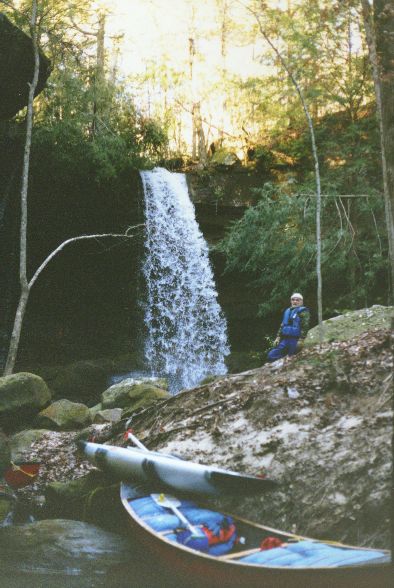
Optimum flow 4.0'. Thompson Creek is a narrow creek which flows south about 2.25 miles until it meets Hubbard Creek. The combined flow of the two creeks forms the Sipsey River. Below the confluence of the creeks, a long pool is encountered; this pool signals the approach of the only rapid on the Sipsey head waters. The pool is dammed at the end with all the water funnelling into a chute on the left side of the river. The chute breaks back slightly to the right at the base of the drop with the rocks obstructing a straight through run. The total drop across the rapid is four or five feet. The rapid is Class II at 2.0' and becomes a Class III at 3.6' (the highest level that I have observed). Below the rapid, large boulders sporadically rest in the river and on the banks. Bluffs line the river down the entire length. A trip up the first large feeder branch south of the rapid will reward the hiker with a spectacular waterfall. The waterfall is about 1/8 mile up the branch and out of sight of the river. Just above the Borden Creek confluence is a small feeder creek on river left; just paddle up the creek and you will be at the base of Fall Creek waterfall. After passing the Borden Creek confluence on river left, it's just a short paddle to the takeout.
As of 2/3/02, there are two log jam portages on Thompson and five log jam portages on the upper Sipsey portion of the run. (Murray Carroll)
Details
-
ClassI (III)
-
Gradient (fpm)
-
Length (mi)8.5
-
Watershed Size (mi2)15.6
-
Put InNorthwest Rd (F.S. 208)
-
Take OutCranal Rd/County Road 60
-
Shuttle
-
Water Quality
 (
1 chicken | 1 = Good, 3 = Gross)
(
1 chicken | 1 = Good, 3 = Gross)
-
Primary Gage
- Sipsey Fork near Grayson 1.5' or 220 cfs
-
Indicator Gage
-
Precip. Gage
Map
Video
Photos

Trip Reports
Thompson Creek
April 15, 2017
Pat W - Columbus, MS
Normally friends and I hike the Bankhead and due to some late storms realized that the Thompson Creek was running strong enough that we could finally be able to float down it. Unfortunately water levels change rapidly. When we originally planned the trip the flow as measured on the Sipsey was 360 cfs with the water level of approximately 1.5’ at the Thompson Trail head. Four days later, and despite some heavy storms in between, the flow was down to 180 cfs and the water level at the Thomson Trail head was barely navigable. But don’t worry because the Thompson combines with Hubbard Creek in approximately 2.8 miles and if you can navigate Thompson without too much dragging once you combine with Hubbard creek you will have no further problems.
We only drove one car so we locked up the Kayaks at the Thompson trailhead. The rock road has been recently repaired from the spring 2016 storms and cars can easily navigate to the trailhead where there is abundant parking. After offloading our Kayaks we drove to the Sipsey Trailhead and hiked 9 miles thru the Bankhead National Forest back to the canoes. There is an unmapped trail the connects trail 204A with the 206 near the Thompson trailhead. Without the shortcut it is an additional 2 miles.
We were able to reach our kayaks and start our float at approximately 1230. As previously stated the flow at Thompson was barely navigable and we scraped rocks quite a bit initially but luckily we only had to get out and drag the kayaks twice. We enjoyed the wonderful scenery at a nice leisurely pace. We did have to portage around some down trees once. After approximately 2.8 miles we joined with the Hubbard and had no more problems with dragging. Shortly after combining with Hubbard we hit the ‘Ship Rock’ rapids. There is the ability to stop and study the rapids before attempting them which would be a good idea if the water levels are high. I’m no expert or classing rapids but I believe these are near a class two even with the low water levels.
After the rapids we continued down the river to the Sipsey Trailhead. There are a couple of areas with large rocks that can result in other rapids depending on water levels but since the flow was low they were entertaining but not truly rapids. We had to port around about five log jams but the scenery definitely made up for the inconvenience.
Overall I would recommend this ‘float’ for anyone looking for a very beautiful and scenic trip. If the water level is high enough at Thompson trailhead to float then the entire length will be good or better. If the flow is high you definitely want to scout out your path thru ‘Ship Rock’ rapids.
February 2, 2002
Heather Mitchell
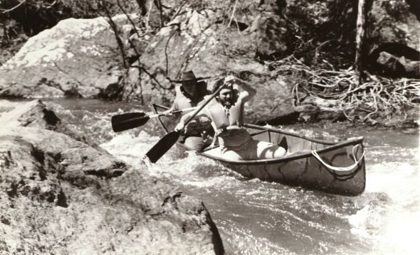
This is a very beautiful and scenic float through the entire Wilderness Area of the Bank Head National Forest. We put in at forest road 208 and the take out is the Sipsey River Recreation Area. The float lasted approximately five and a half hours given we had about eight log jams that we scurried across and under or any which way we could manage. The water current moves slowly, although a good ability to control your canoe would be necessary through some of the tight areas. There is one class two rapid called Ship Rock rapid. This is the first time that many of us have floated this section of the Sipsey River because it is very water dependant and usually is only floatable during the winter months.
Our party consisted of six canoes with nine paddlers. Our trip leader was Bob Barnett. The paddlers were Brenda Barnett, Johnnie and Nancy Shue, Robert Andrews, Orrin Long, Ron Thomas, Jon Mitchell and myself. Our heroes for the day were Jon Mitchell, Johnnie Shue and Orrin Long. They impressed us with how confident they were at balancing on top of the wet slippery logs while pulling our canoes across the log jams. Meanwhile, the rest of us were busy climbing out of our canoes while carefully moving out of the way without falling into the cold water. Some of these log jams were absolutely enormous, which we took pictures of for evidence. One of these days Jon and I are going to see the Sipsey River when the water level is as high as we have seen evidence of such as the unbelievable log jams.
We stopped for lunch at Ship Rock where Doug Brewster and some friends were camping. They were gracious enough to share their nice warm fire, which made our lunch stop more comfortable. After lunch we walked down stream a "little" ways to take a closer look at the Ship Rock rapid. This class two rapid is floatable but tricky. Most of us chose to portage around because of the fact that the air temperature was around 43 degrees and we were concerned about getting wet, considering we still had several more hours to float. Bob and Brenda chose to go through the rapid. Unfortunately, Jon and I missed them run the rapid because we were waiting upstream. We were next in line but lost our confidence when we learned of our mentors' outcome. I hope someone was able to catch that rare event on film. Ha!
I feel that we all had a good time and would recommend this float to anyone who would enjoy soaking in the scenery of some of the most beautiful country you will ever see.