East Fork Little River Lower
-
RunEast Fork Little River
-
ClassII (III-)
-
Put InLake Lahusage Dam (off Riverhaven Rd)
-
Take OutForest Rd. 04 or Rt.35
-
Length (mi)11.3 or 14.3
-
Gradient (fpm)19.2'/mi. to confluence, 5'/mile confluence to AL 35
-
Watershed (mi2)35.6
-
Primary Gage
- None - but LRC is good Visual
-
Indicator Gage
- LRC 900 (1500 much better)
Description
A truly rare species in Alabama, the East Fork of the Little River can actually be run as a whitewater overnighter. This section of the river is wide enough for a tandem boat, has sufficient rapids to make things interesting, and is fairly long with placid stretches well suited to two blades per canoe. Primitive camp sites can also be found along the river. Be sure to check with the National Preserve to make sure they are open. Despair not if you want to run it in a day, that can be done as well.
The put-in is below scenic Lake Lahusage dam, which can be run as a park-and-huck at levels of 1,800 cfs and above on the main LRC gauge. Half a mile downstream, a low head dam can be portaged on the right or run anywhere at low water. All of the rapids occur before the confluence with the West Fork of the Little River at mile 8. At 1700 cfs, the river is pleasing Class II with two light Class III rapids and some big pools. Eddy turns are not an essential requirement. The last couple miles above the confluence are pretty flat.
The remaining 6 miles of river down to the Hwy. 35 take-out are Class I with some decent waves at good water. The first half of the combined section is almost completely flat but the 2nd half moves along and has a couple waves. 900 cfs is the extreme minimum while 1500 cfs is the start of the nice range. This run could be made with a good bit of water (2500 cfs? or more?) and things would really move coupled with good play spots. The class III's would rock at higher water. There are no logs to deal with as of 1/2002. (assistance from Murray Carroll)
Notes on the section below the confluence from Jason Smith:
Access along FS road 5 and FS road 3 is fine in 2wd if you have good clearance. Numerous hard bottom stream crossings, but gravel improvements have made the roads much better. 500 cfs is the minimum for this section, and 750 or above is a much cleaner run. Can be run at lower level than the East Fork, which needs at least 1000 cfs... This is a nice lower water alternative for the intermediate boater. Starts as easy Class I-II, then rapids are solid class II from Hartline Ford to HW 35, with one class II-III drop. Total run is 6.0 miles. Alternative run, putting in at Hartline Ford has more action and is a shorter - about 4 miles. This great short run that can be done in 2-3 hours.
Road 05 would be the best take-out on river right, while Road 03 is OK on river left. Road 03 is rutted, but not too bad in a pick-up, or anything with ground clearance. 4WD may be needed on some of the hills if it has rained recently. See the above access map. Three or four more miles bring you to route 35 upstream of the falls. The river below the confluence is largely flat. The alternate take-out about 3 miles below the confluence avoids some flatwater, but delivers a long shuttle. To get to the alternate take-out in 1997, you took Crest Rd. north off Rt. 35 (east of Little River), drove about 3.4 miles and then turned left on forest road 02. After following 02 for 1.4 miles, turn right on road 04 and you'll be at the river.
2013 update on takeouts: The Backcountry road number 5 would be impassable to anything short a 4 wheel vehicle with off road tires. The best take out now is river left off Back Country road 2 and then turn onto Back Country 04 to Billys Fork, these 2 roads passable by most cars.
The shuttle is long but simple. From the take-out, go east on 35, then left on CR15. In Menlo, GA, turn left on Hwy 48 and go up the hill to Riverhaven Rd, the last road before the East Fork bridge. The best put in now is river right parking on the road where you can see the dam river right near the entrance to Lookout Mtn Camp. Short scramble down to a put in below the dam. Watch for rebar in the dam debris right below the dam.
Details
-
ClassII (III-)
-
Gradient (fpm)19.2'/mi. to confluence, 5'/mile confluence to AL 35
-
Length (mi)11.3 or 14.3
-
Watershed Size (mi2)35.6
-
Put InLake Lahusage Dam (off Riverhaven Rd)
-
Take OutForest Rd. 04 or Rt.35
-
ShuttleRiverhaven/ Hwy48/ CR15/ SR35
-
Water Quality
 (
1 chicken | 1 = Good, 3 = Gross)
(
1 chicken | 1 = Good, 3 = Gross)
-
Primary Gage
- None - but LRC is good Visual
-
Indicator Gage
- LRC 900 (1500 much better)
-
Precip. Gage
Map
Video
Photos
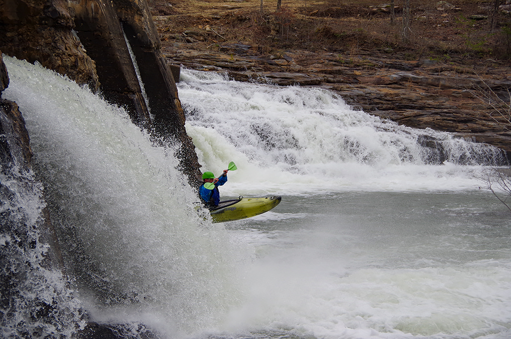
Pike Briggs running the park-and-huck dam drop. (Kellis Kincaid, March 2021)
Dale Culpepper runs a small drop early in the run
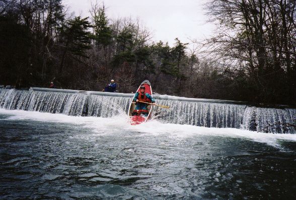
Dave Curry eschews the walk around the 'not so treacherous at this level' low head dam.
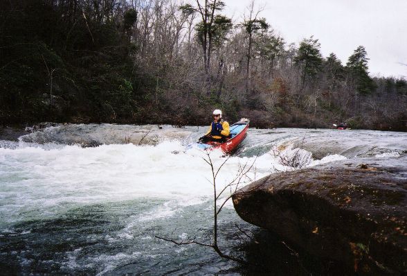
Brenda Barnett heads into a rapid somewhere on the East Fork
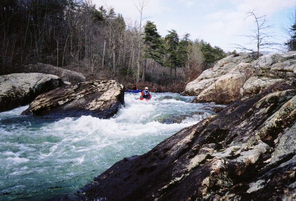
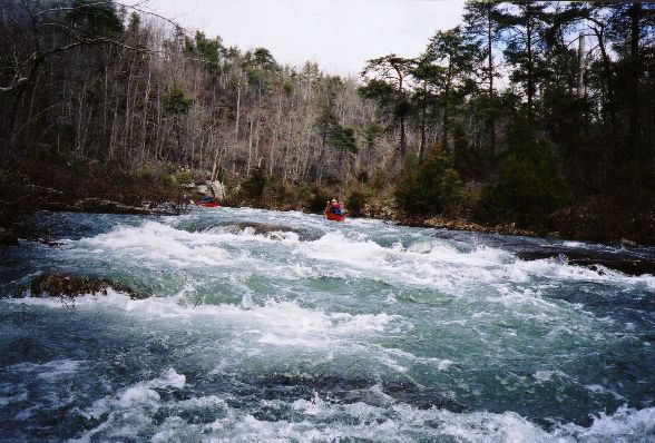
Brenda runs the left side of one of the III- rapids. You could go right of the rock as well.
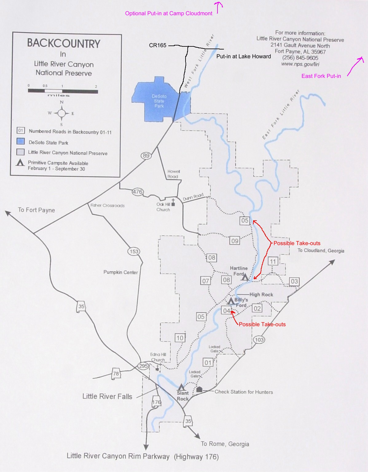
A map of potential access points
Trip Reports
East Fork of the Little River
March 1998
Written by Murray Carroll
As many of you know, Huntsville Canoe Club swaps newsletters with several neighboring canoe clubs. I have made a habit of reading these newsletters whenever I can obtain them. Some really good pieces appear in other club's newsletters and we reprint them in our newsletter when they are of interest to us here in Huntsville. One of my favorite newsletters is from the Tennessee Valley Canoe Club, based in Chattanooga. Through the years, one name kept appearing as the trip leader for overnighters, John Alden. I called John three years ago and got his advice on water levels on the Toccoa River before our HCC overnighter on that small river. In February of this year I obtained the TVCC newsletter and saw that John was planning to lead a canoe camping trip on the East Fork of the Little River (Al); I waited until a few weeks before the trip and called John and asked if Kay and I could accompany him down the river. John said that he would be happy to have us on the trip.
The East Fork of the Little River is one of the two major tributaries to the Little River on Lookout Mountain. Many of us in the club have paddled the canyon and Mark D' led a trip down the West Fork this spring, but no one in the club had paddled the East Fork. John paddled the East Fork the preceeding Thursday, more than a week prior to the trip at around 900 cfs (Little River at Blue Hole; a long way and a lot of tributaries downstream) and reported the river low but runnable. In the days prior to our trip the river fell, rose slightly again and then began another fall to around 750 cfs on Thursday; things weren't looking too good. Just like clockwork, the heavy thunderstorms poured into the area on Friday and the river was running around 1700 cfs by Saturday morning. We met John Alden and Lois Newton (TVCC's newsletter editor) at Valley Head and were joined by Don and Judy Bodley along with their friend Carter at the put-in near Mentone. Our group was made up of two tandem crews and three solo boats.
The put-in is below the dam at Lake Lahusage, a rustic dam with a partial road across the top. The action begins immediately and doesn't let up until the East Fork joins the West Fork 8.3 miles downstream. It is a drop/ pool river, but the current moves nicely through the short pools. Most of the shoals and rapids are Class II, but at least two would rate a mild Class III rating. Foshee's guidebook notes 48 shoals and rapids in the section from Lake Lahusage to the confluence and I would say that is fairly accurate. This first day of the overnight trip is as much as most anyone would want to run with a boat loaded with camping gear. We had no swims on this section, unlike TVCC's 1997 trip when three out of six boats swam (the water was much higher last year). We camped at a really nice site at the confluence of the East and West Forks; ate a leisurely dinner and then indulged in a TVCC tradition; playing Trivial Pursuit, men vs. women. Naturally the men soundly thrashed the gals at the game.
Day two of the trip was a float down the remaining 6.3 miles of river to the takeout on Highway 35. The float was on the clear waters of Little River; this section is only Class I, with one Class II drop, but it flows swiftly and you're back in civilization entirely too fast. After camping on some of the top overnighter rivers in the Southeast, I would rate this at the top for really interesting whitewater. Not nearly as beautiful as some such as Big South Fork Canyon, this has them all beat when it comes to a challange.